It was misty and cloudy. Neither Auden’s Col nor iconic Rabbit Ears that mark two ends of the pass were visible. I guesstimated that we were probably 50 meter away from the Col (pass). I rubbed my nose, it was numb. But, just like me, it was still hanging in there. I stopped to catch my breath, hopefully for just one last time. The climb to Col is littered with crevasses so we were all roped; when one person stops, everyone must stop. After few minutes, we started walking again -- that is lifting your feet and putting it into the step-mark hole on the soft snow firmed by the folks ahead of you. Sounds simple, isn’t it? But if your focus wavers and mind wanders, you will slip (we all did), and your neighbors on the rope will curse you with choicest of phrases while anchoring the rope for you to climb back. It is another matter that you will be consumed pulling yourself up back into the "trail" and wouldn’t hear a word while just hanging on to your dear life. What a waste of cursing!

After what then seemed like eternity, I found Pavan and Sathya congratulating me with handshakes. It felt unbelievable -- after slipping multiple times while negotiating crevasse filled arduous ascent, I was on the top of Auden’s Col! I turned around, detached my harness from the rope, and offered a wide grin and handshakes to JP and Subbu who were closely following me. We were overjoyed. It was 10:30am and has taken us 4:30 hours to climb to the Col. It was okay to give ourselves few moments for it to sink in. Congratulating and backslapping each other felt like an excellent way of spending those moments. Though clouds and near-white-out has denied us the views from the Col and we couldn’t click awe inspiring souvenir photographs from the top, we were still pretty cheerful and a noisy bunch. We proudly unfurled Tiranga (Indian national flag), offered customary pooja and prasad to Gods for our successful arrival at the Col along with prayers for safe continuation of our journey, and distributed prasad-sweets among ourselves.
After around 20 minutes, our guide Balvant decided that it was time to fix ropes for us to rappel down from the Col. He, his brother Ramesh, and some porters got busy in that. Suddenly we noticed Balvant shouting and waving his hands violently. A few boulders from the east Rabbit Ear rolled down with quite a bit of speed and passed very close to where porters were fixing ropes. One porter got slightly hurt, and another moved away just in time else he would have been hit and probably would have fallen hundreds of meters down. Falling rocks made rappelling down risky. Balvant directed us to descend with just our bare hands on the rocks for around 20 meters. All of us took shelter at a relatively safer spot. There was a pin drop silence. My mind was clouded with doubts: what was about to happen, would all of us be able to climb down the Col unhurt?
Seeds
While my Tapovan - Nandanvan trek, I learnt from my guide that two of the hardest treks in Garhwal Himalaya start from Gangotri:
- Kalindi Pass: the Gangotri valley trail that we had taken to Nandanvan - Vasuki Tal goes to infamous Kalindi Pass and ends at Badrinath
- Auden’s Col: goes through Rudugaira valley to Auden’s Col and ends at Ghuttu village, and it can be combined with Mayali Pass to go all the way to Kedarnath
There is a legend that in ancient times, glaciers were really high. There used to be a single priest to take care of four temples: Badrinath, Kedarnath, Gangotri and Yamunotri. He would trek to all of these temples everyday to offer prayers. I guess being superhuman would have been the foremost qualification to become that priest.
There is also another trail in the valley between Gangotri and Rudugaira valleys, that goes to beautiful Kedar Tal, and offers views of beautiful Thalay Sagar and Bhrigupanth peaks.
Auden’s Col
Auden’s Col (wikimapia) is a pass connecting Rudugaira valley and Bhilangna valley, named after John Bicknell Auden, a British Geographical Survey officer, who first discovered it in 1935 and crossed it in 1939. The pass is at 5490m altitude and connects the ridge coming from Gangotri III (6580m) peak on the north-west and the ridge coming from Jogin I (6465m) on the east, and also binds a glacier coming from Jogin I on the north side of Rudugaira valley, and deadly Khatling glacier on the south side of Bhilangna valley.
Rudra ganga stream or Rudragairu (gairu means deep) or Rudugaira gad drains Rudugaira glacier and eventually flows into Bhagirathi (Ganga) river near Gangotri, and Bhilangna river originates from Khatling glacier and meets Bhagirathi near Old Tehri.
Beginning
During early summer in 2010, Jyoti Prakash Gupta (JP), a veteran trekker in Himalayas, asked me if I would be interested in Tri Pass trek starting from Gangotri to Kedarnath. In the first part, it would take us to Kedar Tal, and then we crossover from Kedar Ganga valley to Rudugaira valley through a pass called Patangini Dhar. In second part, we will cross Auden’s Col and trek over Khatling glacier to the origin point of Bhilangna river. In the last part, we will switch to Mayali Pass trail to reach Kedarnath. This was going to be two weeks long trek. I realized that it was something way harder than any trek I had done. Besides, I was too busy at work in one of the hardest projects I have even undertaken. I also had my newborn daughter to care for, so I wasn’t going to get much time to prepare for. But considering JP’s vast experience, and caliber of other team members, I felt in my guts that stars were aligned. Offer was too alluring to let go, so I grabbed it with both hands :-)

Abhilasha (aka Khukhari), Jyoti Prakash (aka JP baba), Pavan, Sathya (aka Solo Trekker), Subbu (aka Madrasi Mountain Goat) and I met a couple of times to get to know each other, and also went for a night trek to Skandagiri. JP started an email thread with his trademark Excel sheet that had tentative plans, list of supplies etc. (it was a self-organized trek). During this phase, watching JP planning was educating. His vast experience was evident in the way he went about thinking of escape routes at various points in the trek and logistics, how long would it take to reach safety from each of those points, and evaluating altitude changes to ensure appropriate acclimatization and avoiding Acute Mountain Sickness (AMS). He hired the best guide (Balvant) known for this trail. He got a cook who was an accomplished guide in his own right. He found that another team was attempting Auden’s Col and Mayali Pass around the same time with Ramesh, Balvant’s brother, as guide; so he synchronized our plans that we meet them after crossing Patangini Dhar at Rudugaira. He was obsessively focused on safety and planning for eventualities. Having three guides while crossing the Col is not a luxury available so often. I heard him saying a number of times: first and foremost parameter of a successful trek is everyone comes back alive. All this was quite reassuring, and made my life very easy. I could just focus on my office work and spending time with my a couple of months old daughter :-)
I guess the few things that I did towards preparing for trek were running 4km everyday, and buy the stuff in my share of the shopping list that JP gave. I also read every single blog available on Auden’s Col (some of them were outright scary) and marveled at stunning photos. I figured that Auden’s Col and Khatling glacier are extraordinary challenging. Kedar Tal, Auden’s Col, and Mayali Pass are separate treks in their own right. To best of our knowledge, only three civilian teams in the history had completed Tri-Pass in a single trek till then. Patangani Dhar had been crossed around four times. Odds were stacked against us.
This was our tentative 14-day plan starting at Gangotri, with two additional rest/buffer days:
- Day 0: Reach Gangotri (2940m), acclimatization trek, visit temple
- Day 1: Trek to Bhoj Kharak (3415m)
- Day 2: Trek to Kedar Kharak (4315m)
- Day 3: Trek to Kedar Tal (4760m) and back to Kedar Kharak
- Day 4: Trek to Patangini Dhar base campsite (4540m)
- Day 5: Cross Patangini Dhar (5085m) and reach Dhabba Campsite (4685m) in Rudugaira valley
- Day 6: Trek to Rudugaira / Auden’s Col Base Camp (4730m)
- Day 7: Trek to Auden’s Col Advanced Base Camp (4975m)
- Day 8: Cross Auden’s Col (5490m), trek on Khatling and reach Khatling campsite (4970m)
- Day 9: Trek rest of the Khatling, cross waterfall area (4300m) and reach Khatling Base camp (3765m)
- Day 10: Cross Bhilangna river (3480m), and reach Chowki campsite (3630m)
- Day 11: Trek to Masar Tal (4550m)
- Day 12: Trek to Masar Top (4695m), Cross Mayali Pass (4990m) and camp (4335m) near Vashuki Tal
- Day 13: Trek Vashuki Tal (4210m), trek to Vashuki Top (4480m), and descend to Kedarnath (3530m)
All altitudes, except the pass, are actual reading from our altitude meter. At Auden's Col, instead of 5490m, our altitude meter showed 5350m in cloudy conditions. Though Google terrain map at coordinates 30.8735°N, 78.8920°E clearly shows the pass situated between 5480m and 5500m altitude lines.
Our actual trek turned out to be a bit different: we did Kedar Kharak (Day 2) and Kedar Tal (Day 3) on the same day, and we were stuck at Chowki campsite for a day due to rains.

Maps: Google Satellite, Tarrain
Bangalore to Harsil
All of us boarded same Indigo flight from Bangalore to Delhi on 27 Aug 2010 afternoon. When we crossed boarding pass counter and about to take the bus to the aircraft, we realized one of our member was still held up at security. We insisted on waiting for the member despite stern warnings from Indigo staff (delays can be costly for them) that flight will leave without us if we don’t board the bus. We tried to explain to the staff that they should assist the stuck-up member at security, eventually they relented and helped, and we all boarded the flight.
We took an overnight train to Haridwar, and then on 28 Aug morning, took a jeep to Uttarkashi. We reached Uttarkashi around 12:00 noon. We rented the equipment from NIM, bought necessary groceries, and met our guide Balvant. Rains were delayed this year, landslides and floods have washed away parts of the roads between Bhatwari and Gangnani. Road to Gangotri had opened up that very day. Abhilasha used her connections and arranged an army truck to take us to Harsil army camp. We boarded the truck at 3:30pm. Roads were in really bad conditions. Actually, road was non-existent for several kilometers long portions. It was a bumpy ride, but Subbu slept blissfully all the while! We reached Harsil at 8:00pm.
Day 0 (29 Aug 2010) : Gangotri
We had good sleep in army quarters, and nice warm bath in the morning. While having breakfast in army mess, we chatted with some officers who were about to take up an expedition in the Gangotri valley. Then JP and I went for a troll along Bhagirathi river and Harsil village (2620m), and went to nearby Bhajori temple. It is a Buddhist temple, and actually village too has Buddhist characteristics. Just outside the village, we bought some really juicy apples at unbelievable price and watched sheep shearing.
We started for Gangotri in a jeep around 1pm with packed lunch, and reached Gangotri around 1:40pm. We lodged in GMVN hotel dorm, and went to Gangotri temple in the afternoon to offer prayers. At around 4pm, we went towards Kedar Tal trail for acclimatization, and returned by 5:30pm. Balvant and porters have come to Gangotri by then. JP and Balvant went to Forest Office to sort out permits, and we went to Gauri Kund and hit Pandav Cave trail.

We visited temple in the night for watching Ganga pooja. At that moment, JP and I decided to carry water from Gangotri to do Shiva-abhishek at Kedarnath (just like Kanvaria fetch water from Ganga at Gomukh, Gangotri or Haridwar in Hindu month of Shravan and travel to various Shiva temples to offer abhishek). So we both bought bottles and filled Ganga water. The rule is that the bottle should never be kept on ground or any other surface (so you have to carry it or hang it).
Day 1 (30 Aug 2010) : Bhoj Kharak
We started at 8:15am. Trail to Kedar Tal has quick altitude gain at the start. It goes trough dense forest of chir (pine) and deodar (cedar) trees, and within two hours we were at an altitude of last tree line of bhoj (birch) trees. That is the typical pattern in Garhwal Himalaya: dense forests of chir and deodar upto approximately 3200m, and then birch forests for around another 100m of altitude gain, and then shrubs, and then grass meadows, and then boulders, and finally glacier and snow. By the time we reached birch tree line, Kedar Ganga was flowing at a deep gorge a couple of hundred meters below on our left, and we could not see it, and could just hear roaring sound.
We found an open area in the birch tree forest, and JP told that his phone was getting the cellular signal. He was quite entrepreneurial and started a phone both right there. We all called home, sent SMSes etc., but everyone just refused to pay :-) Trail passes through a couple of landslide and rock fall zones, and there is a scary looking, but safe, spider wall with a ledge just wide enough to have a foothold.

We were walking at pretty good speed, and reached Bhoj Kharak campsite in three and half hour at 11:45am. I must say that this is the worst campsite I have ever seen. It is filled with meter high shrubs/plants and with that a thriving insect life. I was feeling a bit exhausted and rested in a tent, while rest of the team was brimming with energy and went on to do recce. They came back and told that around half an hour walk further, there is a much nicer campsite. Our guide Balvant refused to go further saying that there are rock fall zones there. We didn’t argue and settled there, because guide’s opinion and safety were paramount (though next day, I saw that area, and I also tend to agree that that would have been nicer campsite, but still you should find an excellent guide, and then listen to him).
After lunch, in late afternoon, we mounted ourselves on a huge rock near the campsite, and JP Baba was liberally dispensing gyan :-) He has leant his lessons from previous day, and didn’t ask us to pay. But I vouch that he can be quite skillful Baba down in the plains and some people actually might pay :-) I think Sathya and I were the most difficult to convert, and we just listen to whole spiritual discourse and debate from back benches. Surprisingly, it ended at air dropping Shakira in minimum clothes at our campsite. Unlike trek, I didn’t keep any record of the path we took, turns and crossing on the way, to reach to that end :-)
We had dinner, and I would say not a good sleep. I prefer sleeping on stones that those plants.
Day 2 (31 Aug 2010) : Kedar Kharak and Kedar Tal
We started at 8:30am. It was quite uneventful walk, except that few rock fall zones. JP got mobile network on the way, and he made some calls. He was a nice chap and a quick learner too. He let us make calls and didn’t ask for money :-) I was a bit off-mood and homesick :-) calling up home cheered me up (and I remembered Harivansh Rai Bachchan’s poem बीन आ छेड़ूँ तुझे मन में उदासी छा रही है) We reached campsite at 11:30am. It was a much nicer campsite: nice green grass meadow with Kedar Ganga flowing beneath.
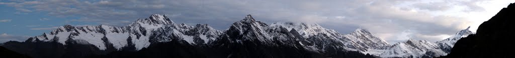
We had done only 3 hours of walk, so we felt quite energetic and decided to visit Kedar Tal same day. There was a big rock, we hosted ourselves on it. A make shift kitchen was quickly set up next to it, and hot soup was served. We left our bags and support staff at the campsite, and started for Kedar Tal at 12:15pm with Balvant and a porter. There was a slightly difficult glacier section on the way, and after that it was a gradual long climb on a ridge. We reached Kedar Tal at 2:30pm. Weather was bad, it was all clouds and even slight rain. We waited there for half an hour for clouds to open, so that we can get glimpse of Thalay Sagar peak and its reflection in the Kedar Tal. Disappointed, we decided to return.
Once we crossed the glacier section on our way back, sky opened up and we got beautiful views of Thalay Sagar and Bhrigupanth peaks. We clicked photos relentlessly fearing that clouds would cover them again. Once out of danger zone, we walked leisurely and reached Kedar Kharak campsite at 5:30pm.


It has been a long day, but I was not tired like previous day. But Khukhari was very tired and was not feeling well, so she didn’t come to Kedar Tal had returned back half way. We were happy that we had saved one day.
JP and I got out of tent at midnight and made all sorts of wild sounds. Some folks thought that there was some wild animal in the vicinity; actually, they were not far off from the mark, indeed JP was in the vicinity :-) Next morning, when Balvant learned that it was us, we got sufficient subtle lashing not to do that again.
Day 3 (1 Sep 2010) : Patangini Dhar base camp
It was kind of a rest day consisting of just a couple of hour walk. We started at 8:30am. Part of it turned out to be quite tough and steep climb, and there were a couple of small water falls. After two hours of trek, we reached the campsite. On the way we saw so many Bramha-kamal (Saussurea obvallata) and Fen-kamal (Saussurea simpsoniana) flowers.
Situated at 4540m, it is a beautiful campsite and offers nice views of whole Kedar Tal valley, and Thalay Sagar and Bhrigupanth peaks. We could see various tributaries flowing to Kedar Ganga. Campsite is small and at slope, so you have to be careful in night so that you don’t walk far and fall. Kitchen tent was some 20m below, and it felt quite a task to walk up and down at that altitude. At sunset, nature briefly offered a riot of red and blue on snowy Thalay Sagar and cloudy sky. It was unbelievable sight.

Campsite was small and at a slope. We kept slipping down the slope inside the the tent. I couldn’t sleep well. Khukhari was having a bad night, she vomited several time. It was clear that she was having symptoms of Acute Mountain Sickness (AMS). We contemplated whether she should cross Patangini Dhar pass. The campsite on other side was at a lower altitude, and crossing the pass didn’t diminish ability to return as there was a route to Gangotri on the other side as well (actually, a more frequented route). Tradeoffs were:
- she might recover and get better acclimatize by climbing the pass and then sleeping at a lower altitude next day and then could continue further; vs.
- she might actually get worse due to altitude gain while climbing the pass, making return more difficult and delaying recovery, or even turning it into a much more serious condition.
Finally,she wisely decided to return because only clinically proven remedy of AMS is to reduce altitude, and climbing the pass would have increased altitude by 500+ meters, and it had potential of worsening her condition fatally.
Day 4 (2 Sep 2010) : Patangini Dhar (5085m) and Dhabba Campsite
Abhilasha returned to Gangotri very early in the morning with our guide Balvant and the porter. We were to climb with our cook cum co-guide to Patangini Dhar. Balvant was to return from Gangotri by next day and join us in Rudugaira valley.
We started at 8:30am. Climb to Patangini was really steep, and upper region was like rocks littered on grass. It was difficult for me, but it was quite a safe climb. Some rocky patches seemed like a garden of Bramha and Fen kamals. We reached the pass at 11:30am, it was rocky with some grass thrown in between. It was raining a little. After spending 15 min., we started to decend. I was astonished to see that Balvant had come back by then and joined us.

Descending on scree slope of the pass to Rudugaira in rain was tricky. Wet rocks were slippery and loose (I slipped once, but controlled quickly). It was a slow and tiring descend for me. We reached at campsite at 1:30pm. Campsite was completely covered for clouds, and opened up only for a very short while. So, we didn’t get any view of the peaks.
To anyone planning trek to Kedar Tal, I would suggest to consider crossing Patangini Dhar and returning to Gangotri through Rudugaira valley.
Day 5 (3 Sep 2010) : Trek to Rudugaira / Auden’s Col Base Camp
We started early at 7:45am. We got nice views of Gangotri peaks across the Rudugaira glacier on the right, and Jogin peaks a little ahead on the left. Towards the end, we got the first glimpse of the Auden’s Col. It still seemed so far away. It was almost a flat walk on ridges. We barely gained 50m altitude that day. But it was 5 hour long walk, we reached campsite at 12:45pm. Campsite was on the scree on glacier, we could hear sound of stream beneath at a couple of places. It was tough to sleep on uneven stony surface.

Day 6 (4 Sep 2010) : Auden’s Col Advanced Base Camp
We started at 8:30am. It was going to be a short day, in fact kind of a rest day. We could have easily covered it previous day. It was quite cloudy, but we could get glimpse of Gangotri peaks, though Jogin peaks were almost always in the clouds. Rudugaira glacier on the right became wider and quite prominent. There were a lot of tables -- a stone forming the top on snow base -- on Rudugaira. As we approached the pass, ridge became narrow. Now on the left, there was glacier coming from Jogin. We reached the campsite at 11:15am. It was just below the col and on the scree on Jogin glacier. It was same story as the previous day: sound of stream beneath at a couple of places, and not so good sleep on stones. Besides, we were sleeping at 4975m altitude, highest so far in the trek.
We met the other team guided by Balvant’s brother Ramesh that came through Rudragaira. So now onwards both teams together had three guides. Next day was the big day. Col was right in front of us, and we were all excited. We just hope that weather doesn’t turn bad.
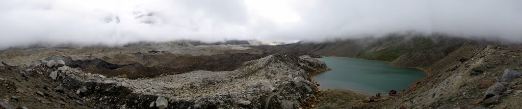
Day 7 (5 Sep 2010) : Cross Auden’s Col (5490m), reach Khatling campsite
We started getting ready at 5:15am, we were late. We wanted to avoid sun as much as possible, as snow plodding becomes quite difficult as sun comes up. Besides, a long trek on Khatling was waiting on the other side, and in the afternoon, weather can turn bad without any notice. We were ready with harness and gaiters by 5:50am, and started at 6am. Initially the ice was hard and slippery, but after few minutes it felt okay. By 6:15am we reached at the base. Col is littered with crevasses. Both teams latched their harness in the single rope -- Sathya, Pavam, I, JP, Subbu, followed by the other team. Ramesh was leading us, and our assistant guide was the last. Balvant has already gone ahead roped with porters and marking the trail.
By 6:30am we were pressing on full throttle. But it was difficult, slow, painful trudge on snow. We crisscrossed several portions to avoid crevasses, some of them were huge, monstrous, and scary. We were slowly inching up. At that altitude, taking just a few steps was tiring. Portions of soft snow were difficult. Most of us slipped at least once. Sathya slipped several time, and each time I cursed him for spoiling the nice step-trail that can be easily followed, making it more difficult for people behind. I was focusing on just walking -- one step at a time. And as soon as my mind wandered that probably that’s how my daughter would feel while learning to walk, I slipped. It happened a couple of time, and I am sure JP would have cursed, but I blocked out all random noise :-) Getting up without slipping and coming back to the trail was exhausting. It felt like never ending quest.

After what seemed eternity to me, we reached at the top of the Col at 10:30am. It definitely felt very nice. But it was whiteout at the top due to clouds. We could barely see Rabbit Ears. I was hoping to see Jaonli and Draupadi Ka Danda peaks, and also vista across the Khatling glacier. It was disappointing to miss those beautiful views after climbing such a high and difficult pass. But we were still quite happy and chirpy. We unfurled our national flag, performed pooja and clicked our photos.

After around 20 min, our guide Balvant started fixing ropes with Ramesh and a few porters so that we can rappel down some 100m to the base on the other side of the pass. We were getting ready to descend. Suddenly, I heard Balvant shouting and then saw violently shaking his hands. I was totally confused. In a couple of moments, I realized there were boulders falling from east Rabbit Ear. One of the boulders passed quite close to the porters busy fixing ropes – one got slightly hurt, and another moved away just in the nick of time else he would have been crushed. A chill ran down my spine, I was like what the hell just happened! I don’t know about others, but it frightened daylight out of me.
Falling boulders took away possibility of rappelling down. But we can’t stay at col waiting for rock fall to stop, or how would we know that it has now stopped. Balvant had presence of mind to direct us to descend on rocks a little further away. On our bare hands, we took sheltered at a relatively safer spot. We stayed there for 15 min., there was pin drop silence. I was praying that we all reach down safely, my mind was clouded by worries. One by one we climbed down bare hands on the rocks keeping our bodies close to mountain face. We did it slowly because those were loose rocks, and we feared dislodging those and that would take us down or hurt someone below.
We rappelled the last 50m, which was away from rock falling zone, on ropes. I didn’t rappel, I just slid, it *now* seem fun. But at that moment, I just somehow wanted to come down. I didn’t know that a more than a meter wide crevasse running for the whole width at the base of the col. There was a small snow bridge that one must pass through. As one deviated from the path, people who have already reached down would be yelling to bring that person back to the path. Yes, one’s harness was latched to the rope, but we were in no mood for any more excitement of someone falling and then pulled out of that crevasse. I landed right at the bridge, and unknowingly stopped there for a minute to catch my breath. I inspected around and realized how precarious my situation was. The snow bridge seemed solid, but I was in no mood to test its strength or my luck. So I almost ran from there. From then on, I hardly had any control. I slid for last 10m, and harness saved the day for me.

Balvant was the last man to came down. He coolly collected the rope, and with two ice axes he climbed down on his knees without any safety of rope/harness, as if he was climbing down a ladder. I was floored. Everyone safe climbing down the pass, I was , now, really happy, probably happier than being on the col. I felt like I have cheated death one more time.
Our joy of safe survival didn’t last too long. Ramesh quickly lined us up and roped us and told that the day was not yet done, we have to cross big chunk of Khatling, that is littered with crevasses. It was 12:30 by now. it had It was still snowing a bit. Same routine as morning: Balvant went ahead roped with porters, and rest of use followed Ramesh roped in a single rope. Khatling snowfield was indeed literally littered with crevasses, we crossed through at least 100 of them. Eventually we got used to them, they started looking friendly. We didn’t mind asking how they had been, were they feeling cold, or whether anybody was in there. By 3pm, we were on safer ice, so we were off the rope. We strolled through rest of the ice field watching beautiful countless ice sculptures and reached Khatling campsite at 4:00pm.

This was again a campsite on a small patch of rocks with glacier ice field all around. Tents were pitched on the rocks. It has been a looong day, and we had survived. Note that I didn’t say that we had crossed that dangerously difficult Auden’s Col -- that was not the highlight of the day. We had something much more important to rejoice -- we had survived. I was no mood to spoil that joyous mood by sleeping on stone. I asked for my tent to be on the flat and relatively smoother ice surface. Other team mates thought it would be cold, but after a while everyone brought their tent to the ice.
I slept well that night. Little did I know that real nightmare was awaiting us next day.

Day 8 (6 Sep 2010) : Cross rest of Khatling and reach Khatling Base camp at Bhilangna snout
It was such a beautiful morning, sunlight touching ice sculptures and turning them to gold. From the campsite another beautiful valley and pass was visible. JP was saying that it might lead to another route that avoids rest of Khatling and open in Gangi village.

Soon whole area was lit in bright sunlight. I couldn’t resist dancing at such a beautiful location with ice sculptures, peaks, passes and valleys in the background. Later Pavan joined me too. All good things come to an end, and we were ready to roll at 9:15am. Soon we started seeing crevasses again. And then it hit us! After 45 min of walk we were staring at zigzag crevasses intertwined into each other as if these were teeth in a Shark’s jaw. Since these were zigzag, we couldn’t walk in straight line and couldn’t rope. We reached waterfall area at 10:30am.

Balvant said that crossing glacier instead of tricky waterfalls will save time, so we continued on glacier. Well, that remaining part of Khatling was even worse than whatever we had seen so far (though might still have been better than crossing waterfalls, I don’t know). There were only crevasses or edge of crevasses. Crossing them was the scariest thing I have ever done in life. At some places, we were walking at the edge of crevasse with barely half-foot hold on the ice, leaning on the slope, and prayers on the lips. It was such a maze of crevasses, crazy crisscross puzzle that I could solve only by being totally numb and following the guide.

We reached at the end of Khatling glacier at 1pm. We passed through Khatling snout where Bhilangna river originates, and then cross a long rock fall/ boulder zone. We reached Khatling / Bhilangna campsite at 2:30pm. Seeing green grass and shrubs felt heavenly.
I can’t tell how happy I was. I decide to shave and take a good bath (including head bath) in ice cold water of Bhilangna, that will probably give some idea of how happy I was. Oh boy, that water was numbing, but didn’t match those crevasses. As I took bath, I couldn’t feel parts of my body temporarily, but I actually felt alive. By 4:30pm, I was ready and shining like a new penny.
We had lavish dinner that day and had a campfire. We sat around soaking the heat, it felt nice. Support staff, JP and Sathya called it a day and went in their tents to sleep. But Subbu, Pavan and I were in full enthu! We were busy first with our Light & Sound show. Later, we started showing our Light & Shadow skills using headlamps and creating shadows of various creatures on JP’s tent. Finally JP couldn’t take it anymore, he came out and forced us to end our party. We protested that it was only 9pm, but it failed to impress him. So we said our good nights.

Day 9 (7 Sep 2010) : Cross Bhilangna and reach Chowki Campsite
It was a summy morning, and the Chowki campsite wasonly a 3-4 hour easy trek. We started at 8:30am and strolled through beautiful Bhilangna valley. Later it started raining. We crossed a makeshift bridge made of wood and leaves over a ferocious Bhilangna. Now that seemed scary, but at that time we were conditioned by previous two days and it was just kid’s play. After crossing the bridge, we took shelter below a huge rock because rain was quite heavy. When rain relented, we trekked and reached Chowki campsite at 3:30pm. We found there was another gang of profs from University of Cincinnati to collect rock samples for their research on dating the glacier.

Chowki is a nice campsite on a grass platform around 10m above the bank of a stream. There was plenty of space to roam around. I spent evening walking near the stream. There was a herd of around 500 sheep across the river.
Day 9a (8 Sep 2010) : Lost in rain
It rained whole night, and continued throughout the day. So we were forced to rest in our tents. By evening, we were feeling impatient. What if rain continued next day as well: whether we wait for another day, or take the escape route to Ghuttu. I was hoping that we won’t be forced to make that decision. We were also running low on ration. Balvant went and bought some wheat flour from shepherds.
Day 10 (9 Sep 2010) : Trek to Masar Tal
Raid had stopped by morning, though valley was still covered in clouds. We were happy to continue to Mayali pass, the last leg of our tri-pass journey. We started at 7:45am. It is a beautiful valley surrounded by beautiful peaks. By 8:30am, there was quite a bit of sunlight. Peaks were shining, and we could see patches of blue sky. We was quite long trek. That day is now hazy in my memory, but I think we crossed a number of ridges, and also one or two small streams. But what I do remember is that the last part had a steep climb. It drained me out. We reached Masar Tal campsite at 11:45am, I had no energy left by then. That day, we had steepest altitude gain (900m). We were of course very well acclimatized by then, but to anyone who is just doing Mayali Pass, I think it would be prudent to have a campsite between Chowki and Masar Tal.

JP was in bad shape, it came after at least an hour later. Subbu was keeping him company till the last 100m of or so. Subbu came and told us, "JP की बहुत फटी हुई है." JP seemed to have had food poisoning. He was fine by evening. We all climbed up 50 meters to Masar Tal in the evening. It is a beautiful small lake of crystal clear ice cold water, with thin and sharp stones surrounding it. One of the porter was telling that Masar Tal is an important holy site for local village. Every year, the procession of the village deity visits to the Tal.
Day 11 (10 Sep 2010) : Cross Mayali Pass (4990m) and camp at Vashuki Tal
This was the D-day for the last pass in our trek. We were filled with energy as well joy of having made it so far. We could see fresh snow in the higher reaches. It seemed that when we were stuck in rain at Chowki campsite, it was snowing up in the mountains. We started at 6:45am, and in few minutes we were at the Masar Tal. We offered prayers for safe passage through the pass. We reached Masar Top at 7:45am. It was nice moderate climb to the base of the pass, but I think our scale of measuring difficulty was skewed by now. We reached at the base of the pass at 8:30am. On boy! what a pretty site it was! There was a semi frozen lake at the base of the pass with big floating ice blocks. The pass was covered with virgin snow, and hills around looked like chocolate cake with snow-white frosting.
After clicking photos, we started the long climb to the pass. It was gradual easy walk on beautiful white virgin snow, with bright blue sky over the snow sprinkled mountains with some customary clouds thrown in. There were some crevasses on the way, but compared what we had seen in Khatling, those were quite easy to navigate. We were not roped and simply jumped over them.

We reached the top at 9:45am. Looking downhill where we came from was like looking at a grand painting. I haven’t seen such a clear bright sunny day ever in Himalayas. We just couldn’t stop clicking our cameras. We couldn’t get enough of it. We were greedy, and wanted to capture it in photos as much as we could. Finally we managed to snap ourselves out of that hypnotic sight, and unfurled our natinal flag and shouted at top of our lungs.

By 10:20am, clouds started gathering, and by 10:30am, it was white out. It reminded us how sudden weather change can be at that altitude in Himalayas. We rushed to descend, and in about 10 min. reached beautiful twin Peenya Tal, and soon we were at boulder zone. I used to be among last, along with JP, to the campsite, but that day I wanted to be first so that I can pick a nice spot for my tent. It was going to be the last camping day, and I wanted to have a good flat soft surface to sleep. That day, I finally did what I thought I had lost ability of: I ran on the boulders! A beautiful misty valley below was waiting for us. We reached campsite at 12:40pm, it was a couple of kilometers before Vasuki Tal. Campsite was nice: a smooth patch of grass surrounded by peaks. As I had reached first, I picked a patch that had no slope for my tent. I was content :-)
We were pretty happy and had gala time. I felt no trace of tiredness, and I was roaming around in a T-shirt, even though it was cloudy and chilly. We watched a beautiful sunset and got into a tent a chatted up to quite late. Dinner was awesome. No, really! And I had a very good sleep (I know JP, my camp mate, didn’t), he he!
Day 12 (11 Sep 2010) : Trek to Vashuki Tal and Kedarnath
We started our final day very early, even by JP’s lofty standards, at 6:50am. We reached Vasuki Tal in 30 min. It is a beautiful lake. While we took photos of the lake, JP took bath in the lake :-)

There was a nice trail from Tal going up to the ridge. We climbed 270m to the ridge and reached Vasuki Top in 45 min. It was a rugged boulder terrain with small patches of grass, with spectacular Kedarnath peak lording over it. For there started a knee breaking extremely steep descent to Kedarnath. Altitude difference between Vasuki Top and Kedarnath town is 950m. There was a nice nice well maintained trail going down to the town, but my knees were paining. I was limping and trying to take soft steps to avoid the pain. Looking at the whole Kedarnath town beside the Madakini river, with the temple at the north end of the town, made me realize that it was quite dense; something that I didn’t grasp in my previous visit to Kedarnath five years back.

I reached the town around 11:00am. Sathya, Pavan and Subbu had already reached, and JP reached sometime after me. We were of course very delighted by our successful completion of tri-pass trek. Everyone, except JP and I, decided to trek down to Gauri Kund and travel to Haridwar on the same day. We both wanted to of course complete our Kanvaria journey and do Shiva-abhishek with the Gangotri water that we had carried all along, but we also wanted to pause and savor the moment. We lodged at the GMVN hotel at Kedarnath. Hot shower and warmth of the bed felt priceless. We went to temple for prayer in the evening. Next day morning, we again went to temple and then trekked to Gauri Kund. After reaching there, we found that the road was closed due to landslides. I trekked around 3km of landslide area and boarded jeep that had come to deliver newspaper to Kedarnath. It took me to Rudraprayag just in time to board a bus coming from Badrinath and going to Rishikesh. While coming down, I kept looking at hills with nostalgia, that I was up there just yesterday! But I was also very eagerly looking forward to lift my daughter in my arms. This beautiful journey was coming to the end.
Epilogue
Balvant is a very capable guide, and with amazing abilities and physical strength in the mountain. He however has two weaknesses (we were aware of both before deciding to hire, because he is the best guide for this route):
- Alcohol. We could almost never reach him on phone while he was at Uttarkashi. We managed it through his brother Ramesh, who is actually a very good organizer. Since we knew it beforehand, we had told him before committing that he should not drink during the trek. And to his credit, he kept his word, except on the day when he crossed over to Rudugaira to meet Ramesh and the other team.
- Money. That also we knew. He added a day extra while computing the travel from Kedarnath to Uttarkashi (typically you hire from Uttarkashi to Uttarkashi), and charged for hotel stay and food etc. I personally felt bad as this was actually very petty for a person of his abilities. We unfortunately had to reduce tips to accommodate extra cost to some extent.
It is an amazing trek, a very challenging one for an inexperienced guy like me. Based on whatever I have read about Kalindi pass, I will rate Auden’s Col technically more challenging. I think that climb to Auden’s Col as well as the descend, and then the following glacier crossing, is trickier than Kalindi. I think the real challenge in Kalindi is that one has to spend in 5000+ meter altitude for five days. I can safely conclude that, Auden’s Col and Kalindi Pass are among the most difficult dangerous treks in Gharwal Himalaya, and most likely in whole Himalaya.
We were probably the sixth team in known history to trek from Gangotri to Kedarnath through Auden's and Mayali, and probably among even fewer to cross three passes in one go. Despite loosing one day to rain we still matched to the fastest team to be able to do that. But more importantly, I cherish the kinship and fondness I developed for my team mates. They all are such an amazing bunch, and they made this trek special. I wish Khukhari (Abhilasha) could have continued with us. I will always remember this trek for the gang, beautiful sights of peaks and valleys, eventful descending from Auden’s Col, that crazy crossing of Khatling, taking bath at Bhilangna (and crossing it next day on that makeshift bridge in rain), and, of course, our light and sound shows :-). Yes, there were some anxious moments, but that would be a hell of a story to tell my grandchildren one day :-) This trek is, and most probably will remain, top 10 moments/experiences of my life. I must say that I was just plain lucky to have been able do that, there is no other way to explain it.
Photo Album (Credit: most photos are by Subbu KL)
Update: For sake of discovering history, I am maintaining here the records of successfully trekking from Gangotri to Kedarnath via high altitude passes; if you have corrections or updates to the following list, please add it as a comment and I will update this list:
- 1939, John Bicknell Auden: J B Auden, A Season's Work in Central Himalaya, Himalayan Journals, Vol. XII, p. 21.)
- Late 1980s, Mr Harish Kapadia and Mr Romesh Bhattacharjee: Harish Kapadia, Across Peaks & Passes in Garhwal Himalaya, ISBN: 8173870977, Indus Publishing, 1999.
- June 2009, Kamal Kandpal: Gangotri to Kedarnath via Patangani Dhar/ Auden's Col/ Mayali Pass
- Sep 2009, Garhwal Hill's team: Auden's Col & Mayali Pass Trekking (Gangotri - Kedarnath Trek)
- Sep 2009, a team from Gujrat: Auden's Col/Mayali Pass
- Sep 2010, Our team crossing Patangini Dhar, Auden's Col and Mayali Pass
- Sep 2011, Crazy Motley's Crew, 4 member team including a Sadhu who gatecrashed at Gangotri without any luggege/clothes, done without guide/porters: Gangotri-Kedarnath Trek